Time-synchronous multiscale remote sensing for biodiversity monitoring
This is a summary of my bachelor thesis submitted on the 9th of June 2024 at the Carinthia University of Applied Sciences in order to obtain the academic degree of Bachelor of Science in Engineering.
Abstract
The loss of global biodiversity due to human activities is steadily increasing. International
programmes are therefore attempting to establish a global monitoring system for
biodiversity. However, no such operational framework currently exists. The Biomonitoring
for Common Agricultural Policy (BioMonitor4CAP) project aims to develop a
biodiversity monitoring system for agricultural and Natura2000 areas. This thesis
contributes to work package 2 of this project. The focus is on using time-synchronised
multispectral remote sensing to infer biodiversity at multiple scales, with the concept of
Essential Biodiversity Variables (EBVs) playing a key role.
The aim of this project is to find out how vegetation-relevant decision-ready information for
Essential Biodiversity Variables (EBVs) in agricultural and Natura2000 regions can be
obtained from analysis-ready remote sensing data and what possibilities multiple spatial
and temporal scales offer in this respect. For this purpose, a comprehensive literature
analysis is carried out, which serves as the basis for a prototype implementation. The
results are evaluated visually and statistically, challenges with the use of multiscale data in
general and in the context of EBVs are discussed and suggestions for future developments
are derived
Research Question
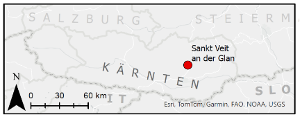
The primary aim of this project will be time-synchronous multiscale remote sensing by comparing the spectral responses of multispectral sensors at different spatial scales for a field test site in Podeblach near St. Veit an der Glan in Carinthia (see Figure to the left).
The EBV (Essential Biodiversity Variable) framework will be used as a theoretical basis for these observations and subsequent data analysis (Pereira et al., 2013). The focus is placed on terrestrial vegetation, as it covers over 70% of the earth’s land surface (Jensen, 2007), is well-suited for remote sensing, and plays a crucial role in the ecosystem as the basis of nearly all primary productivity on earth. Based on the aforementioned points, the following research question was formulated: How can vegetation-relevant decision-ready information for Essential Biodiversity Variables (EBVs) in agricultural regions be obtained from analysis-ready remote sensing data and
what possibilities do multiple spatial and temporal scales offer in this respect?
Methods
At the beginning of the project, an extensive literature review on the topics of EBVs, the
application of remote sensing in their context and the basics of scale levels and the mixed
pixel problem was conducted. The resulting documentation will not be presented here. As stated in the literature review, an EBV cannot be measured directly, but is determined on the basis of a number of DRIs using either a formulaic relationship or expert assessment. These DRIs in turn have different requirements in terms of data acquisition (Sensor, temporal, spatial and spectral resolution). Since deriving all identifued DRIs is not feasible within the scope of this project, the Leaf Area Index (LAI) was chosen as an example.
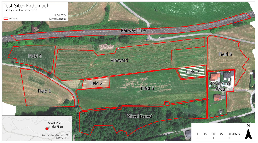
The selected test site in Podeblach was divided into 10 sub-areas of interest for the scope of this project (e.g. Residential area, Vineyard, Mixed Forest, and different types of fields), as can be seen in the image below.
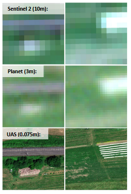
In order to represent three spatial scale levels and therefore a multiscale approach in the analysis, data from three sources with different spatial and temporal resolutions were acquired for the test area:
- Sentinel-2 sat. data from ESA’s Copernicus program
- PlanetScope satellite data from the private company Planet Labs
- UAS data collected by the Carinthia University of Applied Sciences (CUAS) as part of the Biomonitor4CAP project
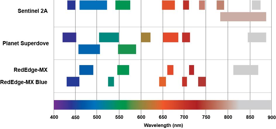
The image below (adapted from MicaSense n.d, p.3) shows a comparison of the bandwidths of all three data sources, excluding SWIR bands.
The Leaf Area Index (LAI) is the only Decision Ready Information (DRI) that is derived in this prototype. The linear relationship between the Enhanced Vegetation Index (EVI) and the LAI is utilised, as described in detail by Boegh et al. (2002). The required data on the three scale levels are acquired from the respective portals, an ArcGIS Pro project is created, and the data are imported and pre-processed. The calculation steps to determine the EVI, and then the LAI for all three scale levels are then carried out. The results are analysed as a whole and for exemplary sub-areas.
Results & Discussion
TBA
References
Boegh, E., Soegaard, H., Broge, N., Hasager, C.B., Jensen, N.O., Schelde, K. & Thomsen, A. (2002)
Airborne multispectral data for quantifying leaf area index, nitrogen concentration, and
photosynthetic efficiency in agriculture. Remote Sensing of Environment. 81 (2–3), 179–193.
doi:10.1016/S0034-4257(01)00342-X.
Jensen, J.R. (2007) Remote sensing of the environment: an earth resource perspective. Prentice Hall series in geographic information science. 2nd ed. Upper Saddle River, NJ, Pearson Prentice Hall.
MicaSense (n.d.) MicaSense Dual Camera Kit.
https://shop.solectric.de/media/pdf/2a/66/7a/spezifikation_micasensedualcamerakit.pdf.
Pereira, H.M., Ferrier, S., Walters, M., Geller, G.N., Jongman, R.H.G., et al. (2013) Essential
Biodiversity Variables. Science. 339 (6117), 277–278. doi:10.1126/science.1229931.
